

What Is Pin to Pin Distance and How It Works
Published on November 4, 2025 • Reading Time: 3 min
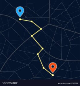
The term pin to pin distance is commonly used in navigation, logistics, and travel planning. It refers to the exact distance measured between two specific points on a digital map — represented by pins or markers. Understanding how it works helps you plan trips, calculate delivery times, or track routes more accurately.
What Is Pin to Pin Distance?
Pin to pin distance means the straight-line or route-based distance between two chosen points (“pins”) on a map. When you drop a pin in tools like Google Maps, each pin marks a coordinate — latitude and longitude. The distance between these coordinates is calculated either as a straight line or by following a specific route.

How Does Pin to Pin Distance Work?
The calculation is based on GPS coordinates and mapping algorithms. Here’s how it works:
- Pin Placement: Drop two pins marking your start and end points.
- Coordinate Detection: Each pin stores latitude and longitude values.
- Distance Calculation: The system uses formulas like the Haversine formula to calculate the distance between the two coordinates.
- Result Display: Maps show the distance (in km or miles) and optional travel time.

Types of Pin to Pin Distance
1. Straight-Line Distance
This is the shortest possible path between two points — ideal for aerial mapping or quick estimation, ignoring roads and obstacles.
2. Route-Based Distance
This follows actual roads or walking paths and is most common in navigation apps, factoring in turns, road types, and traffic.
Tools to Measure Pin to Pin Distance
- Google Maps: Easy “Measure distance” feature for web and mobile.
- MapDevelopers.com: Calculates distances by coordinates.
- DistanceFromTo.net: Quick straight-line calculations.
- Geo Measure App: Perfect for mobile users and custom maps.
Read also — How to Find Pin to Pin Distance Between Two Locations Easily
Applications of Pin to Pin Distance
- Travel Planning: Estimate route time and fuel usage.
- Delivery & Logistics: Optimize routes to save cost and time.
- Education: Geography students use it for mapping projects.
- Fitness Tracking: Measure running, walking, or cycling distances.
Conclusion
In simple terms, pin to pin distance is the digital way to measure how far one location is from another. Whether you’re traveling, managing deliveries, or tracking workouts, it gives accurate and instant results with just a few clicks.